The Four Seasons of an Environmental Scientist
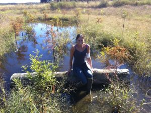
For Environmental Scientists, the year is divided into “seasons.” There’s Planting Season, Frog Call Survey Season, Planning Season (a.k.a. winter), and Bog Turtle Season. Everyone who knows me knows that my favorite is Bog Turtle Season, but once that ends, my second-favorite begins: Wetland Monitoring Season.
The Satisfaction Factor
Monitoring Season is the most satisfying because we find out just how well our planning and hard work have translated into on-the-ground success. Monitoring Season runs concurrently with the peak growing season (mid-June through August) because plants play such an important role in assessing the success of Created Wetlands. This time period allows us to identify the greatest number of species, thus maximizing species richness and diversity.
Wetland Mitigation Monitoring
Most of what we monitor are Wetland Mitigation projects. Wetland Mitigation is compensatory wetland creation as part of our country’s “No Net Loss” wetland policy. In short, this policy requires that wetlands are created to replace those lost. When there is an unavoidable need to impact natural wetlands, regulatory agencies can require mitigation in the form of wetland creation. Wetland Mitigation is usually conducted at a 2:1 ratio of created wetlands to acreage lost.
Wetland Mitigation projects are required to be monitored for 5 years post-construction to ensure wetland function. Because wetlands provide important services such as flood abatement, nutrient cycling, carbon sequestration, and pollutant filtration, we conduct “Monitoring Surveys” and summarize our results into Annual Reports submitted to the regulatory agencies.
They Must Function as Wetlands
The success of a Created Wetland is determined based on how well the area is functioning as a wetland. To qualify as a “wetland” 3 criteria must be met:
- the area must be displaying hydric soils within the top 12 inches of the surface,
- there must be a predominance of hydrophytic (water-loving) plants, and
- hydrology must be present within the top 12 inches of the surface.
These criteria are also used to identify “natural” wetlands. Sometimes people are surprised that “hydrology” does not simply mean the presence of surface water. Many wetlands are dry at the surface but contain shallow water tables or groundwater, thereby meeting the criteria. So, just because an area is dry at the surface does not mean it is not a wetland. We must excavate soil borings to determine what is occurring below the surface.
In addition to these 3 criteria, mitigation projects will contain additional requirements outlined in the wetland permit(s). Common permit requirements include that:
- at least 85% of the planted trees/shrubs survive,
- the majority of the vegetation are hydrophytic natives,
- less than 5% of the wetland is covered by exotic, invasive plants, and
- there is evidence of wetland-dependent wildlife using the area.
- Created Wetlands are usually given 5 years from construction to satisfy these requirements.
Increasing Our Success
Five years is not a long time when referring to wetland maturity. Therefore, thoughtful and informed planning at the beginning can affect long-term success. Because most requirements pertain to the plant community, plant species selection has a huge impact on wetland success. We select species based on the expected hydrologic conditions of the wetland, so, it is important that we design and predict the hydrology accurately. We must know the depths and hydroperiod so we can install appropriate species that will survive and thrive.
To assist with plant selection, I maintain a “percent survival database” of species that we plant into created wetlands. By tracking survival rates per species, we can select those that we know achieve high transplantation rates. This practice maximizes the probability that our wetlands will satisfy the minimum 85% survival rate. We also select species that will attract butterflies and moths, which are the base of the food chain, and will, in turn, attract birds and other wildlife to the area. This practice increases our chances that the wetland will also satisfy wildlife requirements.
During wetland planting, our Scientists place each plant based on the microhabitat and our knowledge of the species. We never plant in rows or patterns. Rather, we place each plant where we think it will do best within the wetland. Every individual plant is important when wetland success will be judged, in large part, on plant survival rates and percent coverage.
From “Dirt Hole” to “Lush Habitat”
I love to watch a (deliberate and calculated) hole in the ground transform into an oasis teaming with wildlife. I am always impressed that a created wetland can develop a diverse native plant community in a few short years. If we, as engineers and scientists, are diligent in our planning stages, then we will have the privilege of reporting a successful wetland community.
Amy J. (Alsfeld) Nazdrowicz is an environmental scientist and Qualified Recognized Bog Turtle Surveyor (DE, MD, PA) for Landmark Science & Engineering. She is a published expert in the effects of woody debris, microtopography, and organic matter on the biotic community of constructed depressional wetlands (2009, Biological Conservation 142 [247-255]; 2010, Restoration Ecology 18 [S2 370-378]).
